Language
 فارسی
فارسی
 English
 تومان
تومان
 ریال
ریال
 EURO
EURO
 USD
USD


برای بزرگنمایی تصویر ، موس را روی آن ببرید
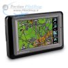
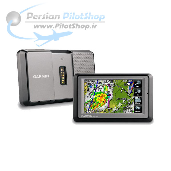
جی پی اس GARMIN AERA 500 GPS
27,264,000 تومان62,877,600 تومان (-57%)
جی پی اس GARMIN AERA 500 GPS
کارکرده با شرایط ظاهری و عملکرد عالی
The Garmin AERA 500 GPS touch screen portable offers easy transition from flying to driving with an intuitive, icon-driven user interface. The aera models feature crisp 4.3” QVGA widescreens, plus the simplicity of a single cable solution for power.
For aviation, aera combines colorfully detailed topography with built-in terrain alerting, high resolution terrain, and airways are also available with selected models.
توضیحات
جی پی اس GARMIN AERA 500 GPS
کارکرده با شرایط ظاهری و عملکرد عالی
The Garmin AERA 500 GPS touch screen portable offers easy transition from flying to driving with an intuitive, icon-driven user interface. The aera models feature crisp 4.3” QVGA widescreens, plus the simplicity of a single cable solution for power.
For aviation, aera combines colorfully detailed topography with built-in terrain alerting, high resolution terrain, and airways are also available with selected models.
Aviation Features and Specifications
* Easy-to-use touch screen interface
* Bright 4.3” diagonal, color touch screen display; 480 x 272 pixels; WQVGA TFT display with white backlight
* Lithium-ion battery – lasts up to five hours, depending on usage and settings
* Flight Plans: 50 with up to 300 points each
* Flight log: At least 30 most recent flights
* Auto time zone – aera will automatically adjust your time zone while navigating
* High-sensitivity GPS receiver with WAAS position accuracy for improved performance and reception
* Simplified PC connectivity, using USB mass storage for easy data base updates at http://fly.garmin.com
* Unit dimensions – 5.3”W x 3.3”H x 0.9”D
* Weight – 9.5 oz (270g)
* Rugged and waterproof (IPX-7)
* Interface with SL30 and SL40 for frequency tuning
Package includes: aera 500, yoke mount, automotive friction mount, vehicle power cable, battery, USB cable, pilot’s guide, quick start manuals
Maps, Databases & Memory: |
|
|
Basemap: |
yes |
|
Navigation database (includes Jeppesen® data): |
yes |
|
Types of Jeppesen data: |
full and ARTCC, FSS frequencies and final approach waypoints |
|
Navigation database coverage areas: |
Americas or Atlantic or Pacific |
|
Preloaded Terrain database: |
yes |
|
Preloaded Obstacle database: |
yes (U.S. and Europe only) |
|
Preloaded SafeTaxi™ airport diagrams: |
not available |
|
Preloaded AOPA Airport Directory: |
not available |
|
Preloaded Garmin FliteCharts®: |
no |
|
Preloaded low & high altitude enroute airways: |
yes |
|
Preloaded private airports: |
yes (U.S. only) |
|
Preloaded street maps: |
yes |
|
Ability to add maps: |
yes |
|
Accepts data cards: |
yes (microSD™ cards) |
|
Built-in memory: |
internal solid state |
|
Waypoints/favorites/locations: |
3,000 (aviation mode); 1,000 (automotive mode) |
|
Routes: |
50 |
Features and Benefits: |
|
Moving map: |
yes |
Patented panel page: |
yes |
HSI (GPS-based): |
yes |
IFR map mode: |
yes |
Traffic Information Services (TIS) alerts compatible: |
yes |
Audible terrain alerts: |
yes |
Terrain resolution: |
standard |
Smart Airspace Feature (generates and displays altitude-sensitive alerts): |
yes |
Automatic logbook: |
yes |
Separate serial and USB interfaces: |
yes |
Voice prompts (e.g. “Turn right in 500 ft.”): |
yes (auto mode) |
Speaks street names (e.g. “Turn right ON ELM STREET in 500 ft.”): |
yes (auto mode) |
Lane assist (guides to proper lane for navigation): |
no |
3-D map view: |
yes (auto mode) |
Bluetooth® wireless technology: |
yes (auto mode) |
Speed limit indicator (displays speed limit for most major roads in the U.S. and Europe): |
no |
Traffic compatible (routes around traffic with a receiver and subscription): |
no |
Custom POIs (ability to add additional points of interest): |
yes (auto mode) |
XM WX Weather & Radio for U.S. & Canada compatible: |
no |